
ECOLEGACY MEDITERRANEAN

Scientific Mapping Studies
Project Posidonia adopts a holistic approach to these challenges. As part of the project, seagrass meadows are mapped in detail using high-resolution aerial imagery and field surveys.
Through these efforts, one of the most comprehensive datasets in Türkiye to date has been created on the distribution and condition of seagrass meadows across the bays surrounding the Bodrum Peninsula.
Seagrass Restoration
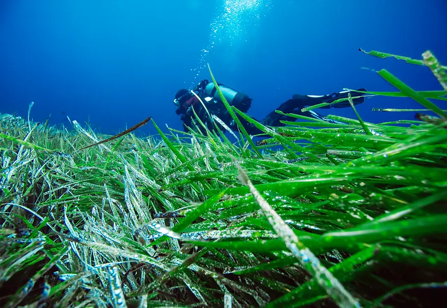
A key component of Project Posidonia is its restoration work. Seagrass shoots under high levels of stress and pressure are carefully collected by trained dive teams and replanted in suitable areas. This method is an environmentally responsible restoration approach that supports the natural regeneration capacity of seagrass meadows. Restoration is applied only when deemed necessary based on scientific assessments.
Ecomooring Systems
The eco-mooring systems implemented in the project are secured without the use of heavy anchoring blocks on the seabed, preventing damage to Posidonia seagrass meadows and preserving their ecosystem structure. By supporting water clarity and underwater ecosystems, these systems contribute to the maintenance of biodiversity. At the same time, they enable sustainable marine tourism and yacht mooring, offering both ecological and economic benefits.
Awareness Activities
Project Posidonia is not only a scientific research initiative; it is also an awareness and engagement program carried out in collaboration with local communities. Through school-based education, citizen science activities, diving events, and public outreach programs, the value of seagrass meadows is communicated to a wide audience. Fishermen, dive centers, boat captains, and students all become active stakeholders in this process.
Long-Term Vision
Through these projects, marine conservation becomes a shared effort embraced not only by experts but also by local communities. In the long term, Project Posidonia’s vision is to contribute to the establishment of science-based and effective Marine Protected Areas around Bodrum. These areas will safeguard Posidonia seagrass meadows, support biodiversity, and provide a strong model for sustainable fisheries and responsible marine tourism.
Green Rangers
Local volunteers play an active role in monitoring, protecting seagrass meadows, and informing the public. The Green Rangers network brings together scientists, divers, fishers, and local residents around a shared purpose, strengthening local stewardship for the protection of marine ecosystems. In this way, the condition of seagrass meadows is regularly monitored, potential threats are identified early, and communities are able to directly contribute to conservation efforts.

Results of the Bodrum Peninsula Seagrass Analysis
Within the scope of the project, the distribution, condition, and pressures affecting Posidonia oceanica seagrass meadows along the coasts of the Bodrum Peninsula were mapped in detail using aerial imagery (drone), underwater observations, and GIS analyses. The study identified approximately 2,185 hectares of seagrass meadows within the shallow coastal zone of the peninsula (roughly the first 10–15 meters in depth). In contrast, around 2,165 hectares of coastal area were found to consist of sandy, rocky, or degraded habitats.
These findings indicate that nearly half of Bodrum’s shallow coastal areas are covered by seagrass meadows, underscoring their fundamental role in the region’s marine ecosystem. The analyses also revealed that coastal development, pollution from urban waste, fish farm operations, marina and boating activities—particularly anchoring pressure—cause significant damage to these habitats.
Based on the resulting maps and spatial data, marine protected area proposals and eco-mooring (ecological anchoring) systems have been developed to safeguard sensitive seagrass basins.
PROJECT POSIDONIA_BODRUM PENINSULA REPORT
Annex (1): Marine and Coastal Threat Map
Annex (2): Boat Numbers and Capacity Study in Bodrum
Annex (3): Violations and Proposed Protected Areas in the Bodrum Peninsula
Annex (4): Aerial Photographic Bay Analyses of the Bodrum Peninsula
Annex (5): GIS Maps of the Bodrum Peninsula